Skip to main content
Defence Technology
Platform-ready product blueprint

GeospatialIntelligenceAnalysisTools

Geospatial Intelligence Analysis Tools help teams improve forecasting and decision support. A custom build can include live feeds, historical trends, thresholds, external signals, dashboards, alerts, and planning views, helping teams improve secure coordination, readiness, and controlled operational decisions.

Workflow
Data
Automation
Reporting

Primary users

Defence Technology operators, managers, analysts

Core data

source data, predictive signals

Delivery model

Web, mobile, cloud, IoT, analytics

Business value

Faster decisions, clearer ownership, better reporting

Workflow
Data
Automation
Reporting

Primary users

Defence Technology operators, managers, analysts

Core data

source data, predictive signals

Delivery model

Web, mobile, cloud, IoT, analytics

Business value

Faster decisions, clearer ownership, better reporting
Executive Value Summary

Business outcomes engineered for Defence Technology.

Operational Efficiency

Streamlines defence technology operations by unifying source data and predictive signals into a single actionable workflow.

Reduction of Manual Work

Replaces fragmented tracking, manual email follow-ups, and disconnected spreadsheets with automated handoffs and role-based approvals.

AI & Decision Intelligence

Provides real-time data visibility, exception alerts, and predictive signals so managers and operators can act on verified evidence.

Enterprise Scalability

Built on modular cloud, API, and multi-tenant foundations designed for seamless integration and multi-region operational expansion.

Platform Architecture

4 connected layers behind this solution.

Experience layer

Role-based workspaces for geospatial intelligence analysis tools users, approvals, alerts, and operational views.

Data layer

Structured records for source data, predictive signals, trends, alerts, dashboards, and decision evidence with audit history, validation rules, and reporting-ready models.

Automation layer

Configured triggers, exception routing, notifications, and decision support for repetitive workflows.

Integration layer

APIs and connectors for enterprise systems, devices, dashboards, data warehouses, and partner workflows.

Techbrain Platform Fit

Built as a product system, not a one-off screen.

Techbrain's product vision is to build reusable technology foundations that can serve multiple industries while respecting each industry's real operational workflows.

Reusable platform core

Geospatial Intelligence Analysis Tools can be built on repeatable identity, workflow, data, analytics, API, cloud, and admin foundations instead of starting from zero every time.

Industry-specific intelligence

Defence Technology context shapes the product rules, users, alerts, dashboards, integrations, and operating decisions so the system feels practical for real teams.

AI, hardware, and data readiness

The architecture can connect AI, IoT, sensors, embedded systems, enterprise systems, and reporting pipelines when the use case requires it.

Long-term product ownership

The product can evolve through feasibility, prototype, release, feedback, compliance review, documentation, and future roadmap expansion.

Capabilities & Key Features

What this product can include.

Defence Technology discovery workshops to map users, decisions, data sources, and adoption risks.

A structured workspace for source data, predictive signals, trends, alerts, dashboards, and decision evidence.

Role-based dashboards that show the right geospatial intelligence analysis tools signals to operators, managers, and leadership.

Configurable alerts, approvals, exceptions, and handoffs that reduce manual follow-up.

Secure records, audit trails, and integration-ready APIs for enterprise implementation.

Outcome reporting for performance, quality, compliance, cost, productivity, or customer experience.

Delivery Roadmap

From idea to operating product.

Discovery to launch

01

Map

Define defence technology users, pain points, data sources, integrations, and business rules.

02

Prototype

Design the geospatial intelligence analysis tools experience with dashboards, workflow states, and decision screens.

03

Engineer

Build the product architecture, automation logic, secure APIs, admin controls, and reporting layer.

04

Launch

Deploy, monitor, measure adoption, and refine the roadmap around real operational feedback.

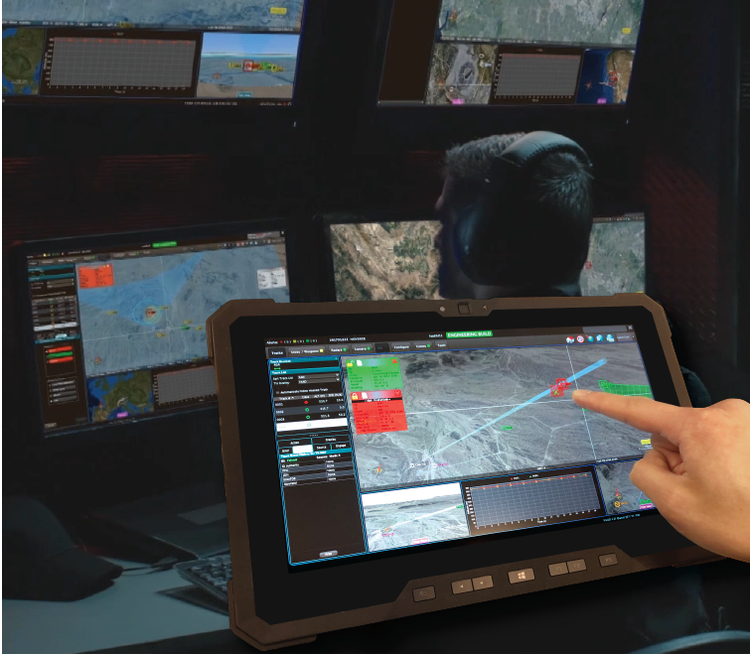
Defence Technology product visual

Designed around real workflow evidence.

Answers

Quick answers for buyers and search engines.

What are Geospatial Intelligence Analysis Tools?

Geospatial Intelligence Analysis Tools represent a defence technology product concept for managing source data, predictive signals, trends, alerts, dashboards, and decision evidence. Geospatial Intelligence Analysis Tools give defence technology teams a clearer way to manage source data, predictive signals, trends, alerts, dashboards, and decision evidence while reducing manual coordination and improving decision speed.

Who uses Geospatial Intelligence Analysis Tools?

It is useful for defence technology operators, analysts, managers, engineering teams, compliance teams, and digital product leaders who need a tailored system instead of disconnected spreadsheets or generic tools.

What business problem do Geospatial Intelligence Analysis Tools solve?

It helps teams replace fragmented data, delayed reporting, manual coordination, and unclear accountability with a single workflow that connects inputs, decisions, actions, and measurable outcomes.

Can Techbrain Networks customize this product?

Yes. Techbrain Networks can adapt the product around business rules, integrations, user roles, reporting needs, security requirements, deployment constraints, and long-term product roadmap priorities.

Portfolio Ecosystem

Related Defence Technology Products

View all 20 defence technology products
Advanced Cybersecurity Threat Intelligence Platform

Advanced Cybersecurity Threat Intelligence Platform

Advanced Cybersecurity Threat Intelligence Platform is a product concept for forecasting and decision support. A custom build can include live feeds, historical trends, thresholds, external signals, dashboards, alerts, and planning views, helping teams improve secure coordination, readiness, and controlled operational decisions.

Military Command and Control (C2) Software

Military Command and Control (C2) Software

Military Command and Control (C2) Software helps teams improve automation and connected control. Techbrain Networks can shape it with sensor inputs, control rules, operator overrides, safety states, audit logs, and maintenance signals, so teams gain secure coordination, readiness, and controlled operational decisions.

Autonomous Surveillance and Reconnaissance Systems

Autonomous Surveillance and Reconnaissance Systems

Autonomous Surveillance and Reconnaissance Systems support real-time monitoring and operational visibility. Techbrain Networks can shape it with telemetry, activity logs, status changes, locations, exceptions, dashboards, and alerts, so teams gain secure coordination, readiness, and controlled operational decisions.

FAQ

Geospatial Intelligence Analysis Tools questions

Direct answers about geospatial intelligence analysis tools solutions, delivery, and next steps.

Geospatial Intelligence Analysis Tools represent a defence technology product concept for managing source data, predictive signals, trends, alerts, dashboards, and decision evidence. Geospatial Intelligence Analysis Tools give defence technology teams a clearer way to manage source data, predictive signals, trends, alerts, dashboards, and decision evidence while reducing manual coordination and improving decision speed.

It is useful for defence technology operators, analysts, managers, engineering teams, compliance teams, and digital product leaders who need a tailored system instead of disconnected spreadsheets or generic tools.

It helps teams replace fragmented data, delayed reporting, manual coordination, and unclear accountability with a single workflow that connects inputs, decisions, actions, and measurable outcomes.

Yes. Techbrain Networks can adapt the product around business rules, integrations, user roles, reporting needs, security requirements, deployment constraints, and long-term product roadmap priorities.

Architectural Blueprint Inquiry

Discuss Geospatial Intelligence Analysis Tools with Techbrain Networks.

Get complete architectural specs, deployment options, and integration roadmaps for Geospatial Intelligence Analysis Tools.

Solution Architecture Team

contact@techbrainnetworks.com

Technical Discovery

Discuss your requirements with our team to define the technical scope and next steps.

Enterprise Security

Air-gapped deployment, SOC2 / ISO 27001 readiness, custom hardware adapters, and 99.99% uptime SLAs.

Product Blueprint Request

Request Solution Blueprint

Preferred Deployment Model:

Cloud SaaS
Air-Gapped On-Prem
Hybrid Edge
Dedicated Instance

Sent via Web3Forms to Techbrain Networks. See our Privacy Policy.

Discovery
Scope Blueprint
Engineering Build